Mayotte - cyclone Chido
Mayotte - Chido cyclone
Cette fiche de métadonnées parent regroupe les différentes couches de données liées à l'évaluation des dommages du bâti à Mayotte après le passage du cyclone Chido le 14 décembre 20204, qui est réalisée dans OpenStreetMap pas des contributeurs et contributrices volontaires à l'aide d'imagerie Pléiade post-désastre. Pour plus d'information sur la méthodologie employée, consulter ces billets de blog :
https://leslibresgeographes.org/cartographie-osm-des-dommages-du-bati-a-mayotte-apres-chido/
Ces couches, toutes librement accessibles et téléchargeables, sont les suivantes :
- des couches nommées avec un préfixe emsr780_ constituées à partir de données récupérées sur https://rapidmapping.emergency.copernicus.eu/EMSR780, qui représentent sous forme de polygones les aires d'évaluation utilisées et sous forme de points l’évaluation des dommages du bâti faite par EMSR Copernicus pour Chido en décembre 2024
- des couches de polygones nommées avec un préfixe hotosm_[id du projet] qui représentent la grille des tâches à cartographier sur les différents projets mis en ligne sur le HOT Tasking Manager pour évaluer les dommages du bâti dans OSM
- 4 couches de polygones nommées avec un préfixe Mayotte_Pleiades_202412 de polygones qui représentent les zones visibles des imageries Pléiade post-désastre et une couche de polygones nommée Mayotte_Pleiades_20241217to20_bounds_clouds_SeverinGeo qui en est le croisement et représente au contraire les zones qui sont toujours couvertes par des nuages sur les 4 imageries, et donc inexploitables pour l’évaluation
- la couche de polygones osm_en_building_damage_copernicus qui représente le bâti OSM avec l'évaluation des dommages réalisée par les contributeurs et contributrices OSM et qui intègre un croisement sémantique avec l’évaluation Copernicus EMSR780. Elle est mise à jour en continu, à quelques minutes d'intervalle de la base OSM
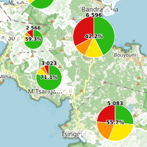
- la couche yt_osm_en_admin_boundary_admin_level_8_communes_stats qui représentent sous forme de polygones les limites des 17 communes de Mayotte avec un synthèse statistique des évaluations des dommages du bâti OSM et EMSR780, leur croisement, le total de bâtiments, le total de bâtiments exploitables pour l’évaluation (car non couverts par des nuages), le nombre de bâtiments restant à évaluer et le pourcentage de bâtiments déjà évalués (parmi ceux évaluables). Elle est mise à jour toutes les heures.
Pour les couches OSM hors Chido (toutes celles dont le nom commence par osm_) également listées dans le point WFS ci-dessous, consulter la fiche https://ifl2.francophonelibre.org/geonetwork/srv/fre/catalog.search#/metadata/10825532-981c-4bf7-900e-bd1b6a6bb19a
Pour visualiser les données, utiliser les liens ci-dessous vers la carte MapStore ou sur les vues cartographiques (en version EN ou FR). Certains indicateurs sont également présentés dans un tableau de bord (en version EN ou FR). Les couches sont également accessibles via ce lien WMS : https://ifl2.francophonelibre.org/geoserver/OSM_YT/ows
Pour télécharger les données, deux possibilités :
- soit le territoire entier dans l'un des formats disponibles via le point WFS « Couches Chido et thématiques OSM EN et FR sur l'ensemble du territoire » ci-dessous
- soit sur une partie du territoire à dessiner soi-même ou à choisir au sein des limites administratives du territoire en question, en utilisant les cartes ou vue MapStore. Des vidéos de démonstration sont disponibles ici : https://llg-collabora.ethibox.fr/s/owY8DQTQpgDr8sw
Actuellement, LE FORMAT GEOPACKAGE N'EST PAS FONCTIONNEL (les couches obtenues sont presque vides de leurs attributs) : préférer le format geojson pour récupérer l’intégralité des noms des champs et le convertir en geopackage depuis QGIS.
This parent metadata sheet groups together the various data layers linked to the assessment of damage to the buildings in Mayotte following the passage of cyclone Chido on December 14, 20204, which is being carried out in OpenStreetMap by volunteer contributors using post-disaster Pleiade imagery. For more information on the methodology employed, see these blog posts:
https://leslibresgeographes.org/cartographie-osm-des-dommages-du-bati-a-mayotte-apres-chido/
These layers, all freely accessible and downloadable, are as follows:
- layers named with an emsr780_ prefix, based on data retrieved from https://rapidmapping.emergency.copernicus.eu/EMSR780, which represent the assessment areas used as polygons, and the building damage assessment carried out by EMSR Copernicus for Chido in December 2024 as points .
- polygon layers named with a hotosm_[project id] prefix, representing the grid of tasks to be mapped on the various projects uploaded to the HOT Tasking Manager for building damage assessment in OSM
- 4 polygon layers named with a Mayotte_Pleiades_202412 polygon prefix, which represent the visible areas of the post-disaster Pleiades imagery, and a polygon layer named Mayotte_Pleiades_20241217to20_bounds_clouds_SeverinGeo, which is the cross-reference and represents, on the contrary, the areas that are still covered by clouds on the 4 imageries, and therefore inexploitable for the assessment.
- the osm_en_building_damage_copernicus polygon layer, which represents OSM buildings with the damage assessment carried out by OSM contributors, and which incorporates a semantic cross-reference with the Copernicus EMSR780 assessment. It is updated continuously, at intervals of a few minutes from the OSM database.
- the yt_osm_en_admin_boundary_admin_level_8_communes_stats layer, which uses polygons to represent the boundaries of Mayotte's 17 communes, with a statistical summary of OSM and EMSR780 building damage assessments, their cross-referencing, the total number of buildings, the total number of buildings usable for assessment (because not covered by clouds), the number of buildings yet to be assessed, and the percentage of buildings already assessed (among those that can be assessed). It is updated every hour.
For OSM layers other than Chido (all those with names beginning with osm_), also listed in the WFS section below, see https://ifl2.francophonelibre.org/geonetwork/srv/fre/catalog.search#/metadata/10825532-981c-4bf7-900e-bd1b6a6bb19a
To visualize data, use the links below to the MapStore map or to map views (in EN or FR versions). Some indicators are also presented in a dashboard (EN or FR version). The layers can also be accessed via this WMS link: https://ifl2.francophonelibre.org/geoserver/OSM_YT/ows
There are two ways to download the data:
- either the entire territory in one of the formats available via the WFS point “OSM EN and FR Chido and thematic layers for the entire territory” below
- or on a part of the territory to be drawn yourself or to be chosen within the administrative boundaries of the territory in question, using the maps or MapStore view. Demonstration videos are available here: https://llg-collabora.ethibox.fr/s/owY8DQTQpgDr8sw
Currently, GEOPACKAGE FORMAT IS NOT FUNCTIONAL (the resulting layers are empty): prefer geojson format to retrieve all field names and convert them to geopackage from QGIS.
Simple
-
Date (Publication)Date (Publication)
-
Presentation formForme de la présentation
-
Digital mapCarte numérique
-
StatusEtat
-
On goingMise à jour continue
- Point of contact
-
Organisation name Individual name Electronic mail address Role Les Libres Géographes
Les Libres Géographes
Séverin Ménard
Séverin Ménard
CustodianGestionnaire
-
Maintenance and update frequencyFréquence de mise à jour
-
ContinualContinue
- Keywords
-
-
LLg
LLg
-
-
PlaceLocalisation
-
-
Les Libres Géographes
Les Libres Géographes
-
OSM
OSM
-
OpenStreetMap
OpenStreetMap
-
open data
open data
-
Mayotte
Mayotte
-
YT
YT
-
-
GEMET
-
-
Afrique
Africa
-
agro-foresterie
agroforestry
-
bâtiment agricole
agricultural building
-
agriculture
agriculture
-
aéroport
airport
-
agroindustrie
agroindustry
-
approvisionnement en énergie
energy supply
-
gestion agricole
agricultural management
-
eau de surface
surface water
-
economie agricole
agricultural economics
-
forêt des zones tempérées
temperate forest
-
centrale thermique
thermal power plant
-
agriculture et élevage industriel
agriculture and cattle industry
-
centre de tri (déchets)
waste sorting unit
-
exploitation agricole
agricultural exploitation
-
route d'accès
access road
-
marais
marsh
-
secteur tertiaire
tertiary sector
-
paysage cultivé
agricultural landscape
-
télécommunication
telecommunications
-
administration
administration
-
territoire
territory
-
zone terrestre
terrestrial area
-
site abandonné
abandoned industrial site
-
terre agricole
agricultural land
-
juridiction administrative
administrative jurisdiction
-
dommage du bâti
building damage
-
Copernicus
Copernicus
-
EMSR
EMSR
-
Chido
Chido
-
TC-2024-000225-COM
TC-2024-000225-COM
-
-
INSPIRE themes
-
-
Habitats et biotopes
Habitats and biotopes
-
Caractéristiques géographiques météorologiques
Meteorological geographical features
-
Hydrographie
Hydrography
-
Occupation des terres
Land cover
-
Unités administratives
Administrative units
-
Dénominations géographiques
Geographical names
-
Réseaux de transport
Transport networks
-
Lieux de production et sites industriels
Production and industrial facilities
-
Systèmes de maillage géographique
Geographical grid systems
-
Usage des sols
Land use
-
Bâtiments
Buildings
-
Services d'utilité publique et services publics
Utility and governmental services
-
Santé et sécurité des personnes
Human health and safety
-
Installations agricoles et aquacoles
Agricultural and aquaculture facilities
-
dommages du bâti
building damage
-
Copernicus
Copernicus
-
EMSR
EMSR
-
Chido
Chido
-
TC-2024-000225-COM
TC-2024-000225-COM
-
-
Access constraintsContraintes d'accès
-
LicenseLicence
-
Use constraintsContraintes d'utilisation
-
LicenseLicence
-
Autres contraintesOther constraints
-
Licence ODbL - données cartographiques © contributeurs et contributrices OpenStreetMap
ODbL License - map data © OpenStreetMap contributors
-
Spatial representation typeType de représentation spatiale
-
VectorVecteur
-
DenominatorDénominateur de l'échelle
- 5000
-
LanguageLangue de la ressource
- Français
-
Character setEncodage des caractères
-
UTF8Utf8
-
Topic categoryCatégorie ISO
-
-
BoundariesLimites politiques et administratives
-
FarmingAgriculture
-
EconomyEconomie
-
EnvironmentEnvironnement
-
HealthSanté
-
Imagery base maps earth coverCarte de référence de la couverture terrestre
-
Inland watersEaux intérieures, Hydrographie
-
LocationLocalisation
-
SocietySociété
-
StructureConstructions et ouvrages
-
TransportationInfrastructures de transport
-
Utilities communicationTélécommunication, approvisionnement et énergie
-
))
-
Reference system identifierNom du système de référence
- EPSG3857EPSG3857
- Distribution format
-
Name Version gpkg
gpkg
shp
shp
dxf
dxf
json
json
csv
csv
xls
xls
kml
kml
- OnLine resource
-
Protocol Linkage Name OGC:WFS-1.0.0-http-get-capabilities https://ifl2.francophonelibre.org/geoserver/OSM_YT/wfs?SERVICE=WFS Couches Chido et thématiques OSM EN et FR pour l'ensemble du territoire
Chido et OSM EN and FR thematic layers for the whole territory
WWW:LINK-1.0-http--link
https://ifl2.francophonelibre.org/mapstore/#/context/OSM_latest_crisis_LLg/1598#/context/OSM_latest_crisis_LLg/1598 Carte MapStore contenant les principales couches Chido
MapStore map containing the main Chido layers
https://ifl2.francophonelibre.org/mapstore/#/context/OSM_latest_crisis_LLg/1136 Vues cartographiques MapStore retraçant l'historique des évaluations des dommages du bâti - version FR
MapStore map views showing the history of building damage assessments — FR version
https://ifl2.francophonelibre.org/mapstore/#/context/OSM_latest_crisis_LLg/1080 Vues cartographiques MapStore retraçant l'historique des évaluations des dommages du bâti - version EN
MapStore map views showing the history of building damage assessments — EN version
WWW:LINK-1.0-http--link
https://ifl2.francophonelibre.org/mapstore/#/dashboard/1549 Tableau de bord MapStore montrant plusieurs indicateurs de l'évaluation des dommages du bâti - version FR
MapStore dashboard showing several building damage assessment indicators - FR version
https://ifl2.francophonelibre.org/mapstore/#/dashboard/1037 Tableau de bord MapStore montrant plusieurs indicateurs de l'évaluation des dommages du bâti - version EN
MapStore dashboard showing several building damage assessment indicators - EN version
-
Hierarchy levelNiveau
-
DatasetJeu de données
Metadata
-
File identifierIdentifiant de la fiche
- 8aad3842-8903-4658-b4d1-81e07c634b5f XML
-
Metadata languageLangue
- Français
-
Character setJeu de caractères
-
UTF8Utf8
-
Date stampDate des métadonnées
- 2025-10-02T13:34:19.456665391Z
- Metadata standard name
-
ISO 19115:2003/19139
- Metadata standard version
-
1.0
- Metadata author
-
Organisation name Individual name Electronic mail address Role Les Libres Géographes
Les Libres Géographes
Séverin Ménard
Séverin Ménard
Point of contactPoint de contact
- Other language
-
Language Character encoding EnglishAnglaisUTF8Utf8FrenchFrançaisUTF8Utf8
Overviews
Spatial extent
Provided by
